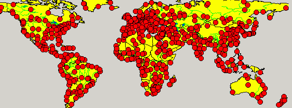
 "setLayerPointSymbol"
Sets a displaying symbol for a point on a specific layer
Synopsis
void setLayerPointSymbol(string strLayer, double dSize, int iMinSize, int
                iMaxSize, int iSymbol);
Parameters
| Parameter | Description |
|---|---|
| strLayer | The layer the symbol will be added to. |
| dSize | Size of the object specified in the coordinate system of your map. Example: when your map is a longitude.lattitude coordinate system, then a value of 1.0 would mean 1 degree ( which would be roughly a shape 40 kilometers wide ). When you use a map that uses meters, this value would be the size of the symbol in meters. |
| iMinSize | The minimum size of the symbol. |
| iMaxSize | The maximum size of the symbol. |
| iSymbol |
The symbol: 0 = POINTSHAPE_RECTANGLE, 1 = POINTSHAPE_CIRCLE, 2 = POINTSHAPE_TRIANGLE_UP, 3 = POINTSHAPE_TRIANGLE_LEFT, 4 = POINTSHAPE_TRIANGLE_RIGHT, 5 = POINTSHAPE_TRIANGLE_DOWN, 6 = POINTSHAPE_RECTANGLE_DOUBLE_EDGE, 7 = POINTSHAPE_TRIANGLE_UP_DOUBLE_EDGE, 8 = POINTSHAPE_CIRCLE_DOUBLE_EDGE, 9 = POINTSHAPE_HALF_CIRCLE, 10 = POINTSHAPE_VALVE, 11 = POINTSHAPE_PUMP, 12 = POINTSHAPE_CIRCLE_HALF_CIRCLE, 13 = POINTSHAPE_CIRCLE_HALF_CIRCLE_DOUBLE_EDGE, 14 = POINTSHAPE_MOBILE_GENERATOR |
Description
Sets a displaying symbol for a point on a specific layer. The size, the maximum and minimum size as well as the type of symbol can be specified.
 Example
The code below will set the layer point symbol to circle.
main()
{
  GisViewer_ewo1.setLayerPointSymbol("COUNTRY", 2, 2, 5,2);
}
Assignment
GIS Viewer


