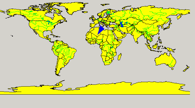
- Introduction to the GIS Viewer
- "acceptDrops"
Specifies whether drop events are enabled for this object.
- "addEmptyLayer"
Adds an empty layer to a map.
- "addPointToLayer"
Adds a coordinate to a layer.
- "addPointToPolygon"
Adds a point to a polygon.
- "addPointToPolyline"
Adds a point to a polyline.
- "addPolygonToLayer"
Adds a polygon to a layer.
- "addPolylineToLayer"
Adds a polyline to a layer.
- "addRectangleToLayer"
Adds a rectangle to a layer.
- "addVarValueColorMapping"
With the color mapping function, you can set different colors for a shape for each range of values of an assigned variable.
- "assignVariableToShape"
Assigns a variable and a value to a shape so that the shape can be selected by the variable.
- "contextMenuPolicy"
Defines how the respective widgets shows the context menu.
- "deleteAll"
Deletes all loaded layers and shapes of the GIS Viewer.
- "deleteLayer"
Deletes one specified Layer.
- "drawTooltip"
Shows a tooltip for the GIS Viewer.
- "exportLayerIndexFile"
Exports a layer index file that contains all the information of a layer.
- "focus"
The attribute "focus"; returns TRUEif the object has the focus.
- "font"
Sets the font of an object.
- "getLayerFieldIndex"
Returns the field index for the specified field name in the specified layer.
- "getLayerFieldName"
Returns the field name for the specified index in the specified layer.
- "getLayerName"
Returns the layer name for the specified index.
- "getNumFieldsLayer"
Returns the number of fields for the layer.
- "getNumLayers"
Returns the number of layers.
- "getNumObjects"
Returns the number of objects in all layers.
- "getNumObjectsLayer"
Returns the number of objects for the layer.
- "getNumPoints"
Returns the number of points in all layers.
- "getNumPolygons"
Returns the number of polygons in all layers.
- "getShapeNameInLayer"
Returns the shape name in a layer.
- "getShapeXCoordinate"
- "getShapeYCoordinate"
Returns the Y coordinate for the specified shape.
- "getXLeft"
Returns the left edge's x coordinate of the currently displayed area.
- "getXRight"
Returns the right edge's x coordinate of the currently displayed area.
- "getYBottom"
Returns the bottom edge's Y coordinate of the currently displayed area.
- "getYTop"
Returns the top edge's Y coordinate of the currently displayed area.
- "hideLayer"
Hides a layer.
- "home"
Zooms a map to the full extent.
- "isActiveWindow"
The attribute "isActiveWindow"; returns TRUE if this widget is the active window, otherwise FALSE.
- "layoutDirection"
Defines the widget's layout direction.
- "loadColorFile"
Loads a WinCC OA color file.
- "loadShapeFile"
Loads an ESRI shape file.
- "maxWidthForText"
Sets the maximum width of the shown area for which the text will be displayed.
- "memoryReport"
Creates a memory report file that shows what is in the memory.
- "moveRectangle"
Moves a rectangle.
- "pan";
Pans a map.
- "PVSSLinkSumAlertToShape"
Links a sum alert data point with a shape in the GIS Viewer.
- "PVSSReceiveSumAlertStatus"
Passes the results of a dpQuery to the GIS Viewer.
- "PVSSSetSumAlertPanels";
- "removePolyLineGradient"
Removes polyline gradient.
- "resetShapeFillColor"
Resets the shape fill color.
- "resetShapeLineColor"
Resets the shape line color to the default value.
- "scrollWheelEnabled"
Defines whether zooming with the mouse wheel shall be possible.
- "selectColor"
Defines the color for the selection window (hold down the left mouse button and draw a rectangle).
- "selectShapeVarAsShapeName"
Sets the entries of a selected Field (Column inside the .dbf file) as names for the shapes of a layer.
- "setAutoZoomExtra"
- "setLayerClickEnabled"
Enables or disables the click events for the GIS Viewer.
- "setLayerDrawAfterText"
Sets the selected layer at the top.
- "setLayerFillColor"
Sets the layer fill color.
- "setLayerLineColor"
Sets the layer line color.
- "setLayerLineStyle"
Sets the layer line style.
- "setLayerLineWidth"
- "setLayerPointSymbol"
Sets a displaying symbol for a point on a specific layer
- "setLayerVisibleRange"
Sets the visible range of a layer.
- "setMinWidthLayer"
Sets the minimum width for a layer.
- "setOpen"
Sets an item to open if open is TRUE and the item is expandable or to close if open is FALSE.
- "setPolyLineGradient"
Sets a polyline gradient.
- "setPropShapeWildcard"
Set a property of various shapes that match a wildcard.
- "setShapeColorByName"
Sets a shape color by the color name.
- "setShapeFillColor"
Sets the fill color for a shape.
- "setShapeIcon"
Sets an icon for a shape.
- "setShapeLineColor"
Sets the shape line color.
- "setShapePVSSSymbol"
Sets a panel reference to a specific shape/point inside the GIS Viewer.
- "setSmoothSteps"
Set smooth zooming steps for a map.
- "setTextVisible"
Sets a text visible.
- "showLayer"
Shows a layer.
- "showShapesAll"
Shows all shapes for a layer.
- "showShapesWildcard"
Shows shapes by wildcard.
- "tooltipDuration"
Specifies how long a tooltip is shown.
- "updatesEnabled"
This attribute specifies whether updates of a widget (for example, a textEdit, slider, progress bar, zoom navigator, LCD number or thumb wheel) have been enabled.
- "updateShapeAndAutoZoom"
Updates a shape with a color and zooms it in.
- "x", "y"
The attributes x and y return the coordinate of an object (e.g. a textEdit, a progress bar, a slider, a zoom navigator, an LCD number or a thumb wheel). x returns the X coordinate of an object. y returns the Y coordinate of an object.
- "zoom"
Zooms a map in or out.
- "zoomByVariableValue"
Zooms all shapes that are assigned to a certain value of a variable.
- "zoomByWildcard"
Allows to zoom to a specific area of the map that is determined using the field entry of the .dbf file.
- "zoomEnabled"
Defines if an area can be selected and zoomed with the left mouse button.
- "zoomLimitMaximum"
Defines the maximum zoom factor that is allowed.
- "zoomLimitMinimum"
Defines the minimum zoom factor that is allowed.


